去る日曜日、鹿島槍ヶ岳は北股本谷を滑ってきました。
ここでは、この山を通して今年の雪の状態を確認したいと思います。
土曜日はあいにくの雨だったため、大谷原で前泊し、当日は3時半出発。
早朝の西沢を詰めます。
We went to Mt. Kashimayari, 2,889m, Japanese Alps last Sunday for skiing.
Here, I'm trying to find out how the remaining snow is like currently in Japan.
As last Saturday was rainy, we started hiking at 3:30 Sunday morning.

林道は所々薄いながらもつながっていて、西俣出合までは快適にシール歩行できました。
西俣出合のスノーブリッジは薄い感じ。
金曜日の雨で落ちたのか西沢はカチカチのデブリランド。
途中板を脱ぎながらも稜線まで詰め上げました。
Forestry road was good condition with enough snow to skin up.
Forestry road was good condition with enough snow to skin up.
Snow bridge at Nishimata-deai was a little bit thin.
Nishizawa valley was full of avalanche debris which were quite hard.
We could skin up to the half way up and then carried skis to the ridge.

冷池山荘はまだ埋まっていました。
稜線はガス。
Tsumetaike-Hut was totally buried.
It was quite foggy on the ridge.

登山道には薄く雪が乗っており、冷池山荘から布引山手前まではシールも使えました。
Trail was covered with snow and we could again skin up to Mt. Nunobikiyama.
Trail was covered with snow and we could again skin up to Mt. Nunobikiyama.

そして、鹿島槍ヶ岳直下。
Here we come right under the summit.
Here we come right under the summit.

奇跡的にガスが晴れました!
And finally the fog is gone!

歩いてきた稜線を振り返って。
遠くに槍・穂高連峰も見えました。
東側の雪庇は半端ないです。
先日雪庇と尾根の間にできた亀裂に落ちて以来、だいぶ慎重になりました。
Looking back the ridge, we could see Yari-Hotaka mountains.
Cornice is fairly developing to the east side.
Looking back the ridge, we could see Yari-Hotaka mountains.
Cornice is fairly developing to the east side.

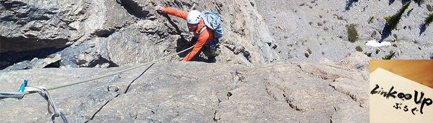
そして、無事南峰に登頂!
And, yes, the summit!

遠くに岩と雪の殿堂が見えました!
まだ黄砂なんかで汚れていないキレイな冬山の姿です。
We could see Mt. Tsurugi 2,999m known as "a palace of Rock & Snow"!
We could see Mt. Tsurugi 2,999m known as "a palace of Rock & Snow"!
Still a beautiful snow mountain being not colored by asian dust yet.

こちらは白馬方面。
Here are "HAKUBA" mountains.
Here are "HAKUBA" mountains.

黒部側に下りたかったのですが、このガスでは恐くていけません。
宿泊装備持ってきたのに泣く泣く日帰りにします。
We wanted go down this way, but could not with such a poor visibility.
We wanted go down this way, but could not with such a poor visibility.

緊張するクライムダウンで北股本谷のドロップポイントへ(清家真太郎撮影)。
またガスが出てこないうちにさっさと滑って帰りましょう。
またガスが出てこないうちにさっさと滑って帰りましょう。
Climbing down a steep slope to the drop-point.
Let's go back down before the fog comes up again.

さあ、行きましょう(清家真太郎撮影)。
カリカリなので慎重に滑りだします。

中間部より本谷を見下ろします。
雪が良ければ最高な斜面。
Looking down from the middle of the chute, Kitamata-hondani.
Looking down from the middle of the chute, Kitamata-hondani.
Good, but better with powder snow though.

振り返って。
Looking back the chute.
Looking back the chute.

谷底は壮絶なデブリランド。
一生分のデブリを味わったという感じがしました。
一生分のデブリを味わったという感じがしました。
本流に合流してからは面ツルの素晴らしいザラメ。
堰堤は埋まり切っていないため、左右を巻きながら下りました。
Bottom of the valley was full of debris...
Bottom of the valley was full of debris...

西沢出合はこんな感じです。
結局ガス待ち、休憩等も含めた行動時間は12時間49分、
累積標高(上り)2088m、合計距離18.78km の長時間山行でした。
Total time including time waiting for fog wiping off: 12 hrs. 49 min.
Total elevation gain 2088m. Total distance 18.78km.
It was a long day.
で、今年のこの雪の状況はどうなんだ?
たまたま顔見知りでしたので、写真の使用をお願いして許可を得ました。
And so how is the recent snow condition?
And so how is the recent snow condition?
Here's a comparison between this year and the last.

こちらは去年の本谷、だいぶデブリが少ないようです。
This is the valley last year with less debris.
This is the valley last year with less debris.

西沢のデブリは変わりませんね。
Condition of Nishizawa does not change much.

ここの状況も同じです。
Hut was buried in the same way.
Hut was buried in the same way.

去年は今年と違って大雪の年でしたが、雪が無くなるのも早かったと記憶しています。
稜線の雪は今年の方が多いですね。
Last year we had lots of snow, but they disappeared quite fast because of rain.
Last year we had lots of snow, but they disappeared quite fast because of rain.
More snow on the ridge this year.

南峰からの下りも大分岩が露出していたようです。
Col between 2 peaks, here they had less snow last year.
Col between 2 peaks, here they had less snow last year.

本谷が快適そうで羨ましい!
以上、trailmarkerさんの記録でした。
以上、trailmarkerさんの記録でした。
まとめると、
1.森林限界以下は去年より雪が少ない
2.アルパインエリアは去年より雪が多い
3.谷底のデブリは去年よりも多い(激しい)?
これからの雪解けにもよりますが、シートラを厭わなければ、
北アルプスのアルパインエリアはもうしばらく楽しめそうです。
全然行っていない南アルプスや富士山はどうなんでしょうね。
気になるところです!
The valley looks much nicer last year!
The valley looks much nicer last year!
Here's conclusion:
1. Below treeline we have less snow this year
2. Alpine area we have more snow than the last year
3. Debris avalanche is more severe than that of the last year
Of course it all depends on coming weather, but
Of course it all depends on coming weather, but
we might have chances to enjoy skiing in the northern Alps for a while (I hope)!